PERMANENT SHM FOR HISTORICAL KOSCIUSZKO MOUND IN CRACOW AND THE POSSIBILITY OF ITS IMPROVEMENT
Rafal Sienko1, Tomasz Howiacki2, Mariusz Maslak3, Michal Pazdanowski4
Cracow University of Technology, Cracow, Poland
Abstract:
The permanent Structural Health Monitoring (SHM) system applied on the historical man made Kosciuszko Mound in Cracow is presented in this paper. A limited data gathering system applied after the revitalization of the mound in 2012 is described at the beginning, followed by the description of the comprehensive monitoring system which was introduced after 2014. It is shown, how the data on relative displacements and deformation of individual layers in the internal structure of the mound are obtained and constantly updated and how this type of information is associated with the corresponding meteorological data. At the same time the observed trends in changes as well as the correlations between individual parameters resulting from climate changes usually following the yearly cycle are indicated. Based on this background a novel data management system is proposed supported by alternative decision strategies. In the first of the compared strategies relatively infrequent actions are preferred, at the high risk of failure with potentially serious consequences, and thus relatively costly, while in the second strategy small scale interventions are preferred, initiated more frequently, but at much lower risk level. Key words: Structural Health Monitoring, historical geotechnical structure, revitalization, string sensors, piezometric sensors, displacements, deformations, meteorological data, decision strategies
1. Introduction
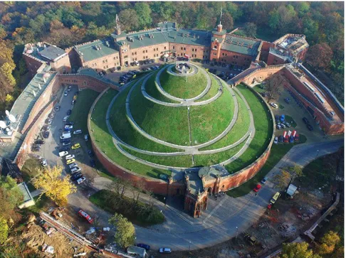
The monumental Kosciuszko Mound in Cracow (Fig. 1) is an artificial hill of 34.1m relative height, heaped up by Poles in the years 1820-1823 in order to commemorate the national hero – Tadeusz Kosciuszko, in recognition of his merits. It is a geotechnical structure especially sensitive to deformation, mainly due to the unfavourable structural material and very steep slopes. In the past it failed several times. The most significant structural failure occurred after the flood of 1997. Then the state of the mound reached the level of building disaster, and this in turn resulted in closing of the mound to the public for
1 Rafal Sienko, PhD Eng., Cracow University of Technology, Warszawska 24, 31-155 Cracow, Poland,
e-mail: rsienko@pk.edu.pl
2 Tomasz Howiacki, MSc Eng., PhD Student, Cracow University of Technology, Warszawska 24, 31-155
Cracow, Poland, e-mail: howiacki.tomasz@gmail.com
3 Mariusz Maslak, PhD, DSc Eng., prof. CUT, Cracow University of Technology, Warszawska 24, 31-155
Cracow, Poland, e-mail: mmaslak@pk.edu.pl
4 Michal Pazdanowski, PhD Eng., Cracow University of Technology, Warszawska 24, 31-155 Cracow,
about 3 years. The intense rainfall induced significant erosion of the slopes triggered the almost total destruction of footpaths leading from the bottom to the top of the mound (Fig. 2). Furthermore, the condition of the mound seriously worsened after the rainfall in the year 2010.
Fig. 1. Kosciuszko Mound in Cracow seen from above, current state.
Fig. 2. Destruction of the mound in the year 1997.
The complex, very expensive renovation did not yield the expected result, and did not stop the destructive forces of nature in their tracks. Due to that fact, in the year 2012, the automatic monitoring system, based mostly on the string sensors, was installed on the
structure. The main purposes of this system were the identification of ground layers behaviour and observation of the temporal changes in the mound deformations, depending on the weather conditions. It was undoubtedly very costly, but the decision was made because of the historical significance of the object and its value to the national heritage. The important from the economical point of view problem of assuring the year round availability of the mound to the tourist traffic also played a role. It is assumed that the monitoring will constitute the basic, reliable and sufficiently precise source of information on all abnormalities occurring in artificially made soil mass, and thus will allow for immediate corrective action and will prevent serious damage.
2. Internal structure of the mound
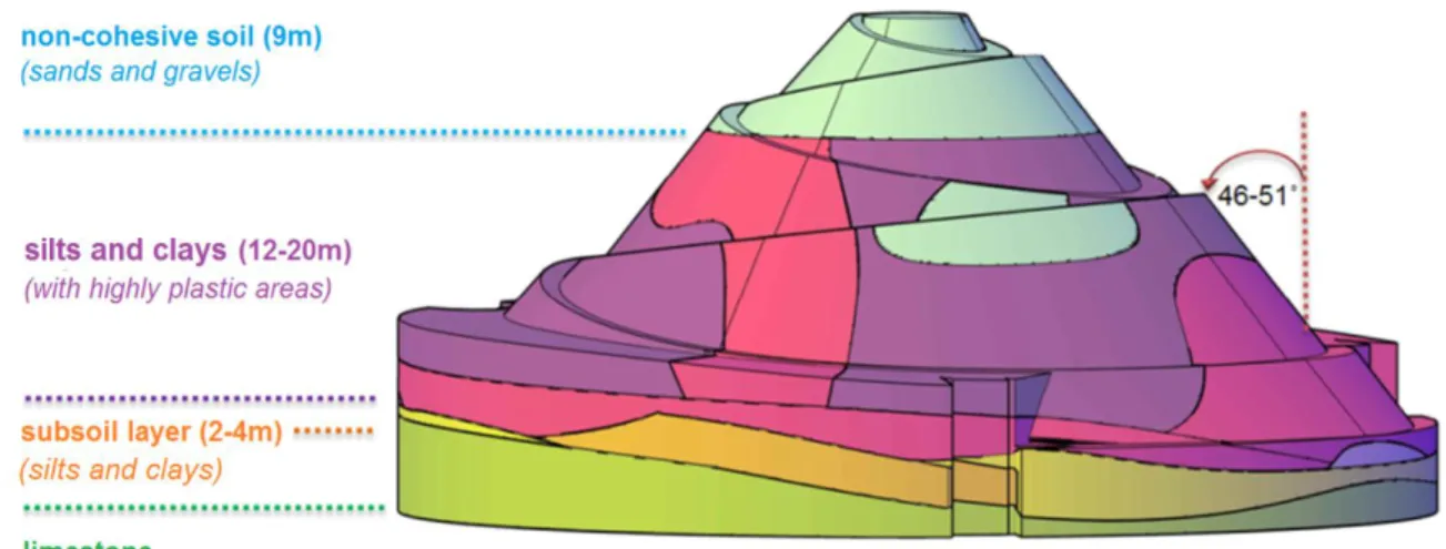
Kosciuszko Mound is an artificial, man-made geotechnical structure erected on a sloped rock bed of indigenous limestone (Fig. 3). It was mainly made of loess type soils, generally in the form of silty clays and silts with a substantial addition of man-made dump ground. Soils of this type proved to be extremely susceptible to the environmental actions during the service time, and especially sensitive to the rainwater infiltration and multiple frieze thaw cycles. The way the mound was heaped up determined extremely unfavourable layered structure of the tambour, exhibiting heterogeneous and locally variable layer thicknesses. Extreme slope of the tambour side, reaching up to 46-51o significantly affects the behaviour of the structure as well, as it substantially exceeds the angle of internal friction of soils used.
Fig. 3. Internal soil structure of the Kosciuszko Mound. 3. Description of the SHM system applied on the mound
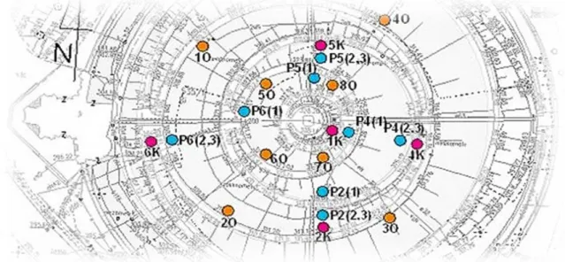
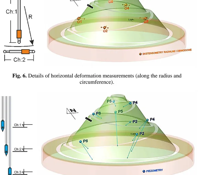
The monitoring system applied in 2012 yields detailed information on the vertical displacements and hoop as well as radial deformations [1]. Location of sensors used to perform such measurements is depicted in Fig. 4. Vertical displacements are measured by the vertically oriented string sensors (Fig. 5) installed at five locations. The horizontal deformations are measured by another group of string sensors [2] installed at the perimeter of the mound and oriented circumferentially and radially towards the inside of the mound structure (Fig.6). The pore water pressure within the interior of the structure as well as the humidity of the top layer are monitored as well by piezometric sensors located in four measuring stations, at three different depths (Fig. 7). All the string sensors have been equipped with thermistors in order to measure the soil temperature at respective measurement stations. The obtained results are related to the geodesic measurements and
measurements of inclination as well. They are correlated with meteorological data provided by a weather station, constituting a part of the monitoring system.
Fig. 4. Horizontal projection of the mound with indicated locations of measurement stations (denotations: K - sensors measuring vertical displacements, O - sensors measuring
horizontal displacements (radial and circumferential) and soil humidity, P - sensors measuring pore water pressure and humidity of the external soil layer.
Fig. 5. Details of vertical displacement measurements.
Detailed geological analyses resulted in the installation of a permanent monitoring system. This action allowing for continuous observation, within the whole mound volume, of the very heterogeneous and mostly man-made, layered and water permeated soil structure was presumed to be the only possible technical solution warranting future trouble free service of the mound.
4. Implementation of VoI analysis
In order to more or less reliably estimate the Value of Information (VoI) for the considered mound and the monitoring system installed on it one should at first estimate the value of the mound itself, treated as a historical monument. It is difficult to come up with
an unambiguous value, as one must take into account above all its historical value related to the national cultural heritage. Therefore it is not only the value of the structure as such, built from a specific material at given expenditure of work effort. One should take into account contexts of various types, even the unquantifiable ones such as emotional value. If such approach is used this object may turn out to be priceless for many. One may also estimate the value based on the insurance premium the local and/or state authorities were willing to pay to insure the structure against complete loss. Whichever method one would prefer to use, these values would not be objective. It is also not the actual cost of installing the monitoring system described above on the mound in question and for its socio-economic determinants in order to see if such an operation would be profitable for society. This monitoring already exists, and one may only think about its improvement or extension.
Fig. 6. Details of horizontal deformation measurements (along the radius and circumference).
Fig. 7. Details of the pore water pressure and external layer humidity measurement stations.
In our analysis we suggest that the VoI analysis should be treated somehow conditionally, subject to the condition, that the results of monitoring applied are available
to the potential user, but some expenditures need to be borne to get these results. Thus the first stage in the procedure proposed by us would be the specification of various failure classes of considered structure, differentiated by the consequences of occurrence. Calculations of this type need to be accompanied by the qualitative and quantitative risk analysis. We propose at first to define and quantitatively describe a local failure mode, occuring rather on the surface and extending over a limited area. A small, but unequivocally determined failure consequence shall be assigned to such phenomenon. Subsequent failure types, defining increasing threshold consequence coefficients would denote increasingly global character of the observed destruction. These would be not only surface damage or deformations but also deformations extending inwards, such which may result in, for instance, loss of stability of the whole slope. At the end there remains the identification of global failure mode for the whole structure as an incident having the highest failure consequences by value. The monitoring results allow for calculation of time dependent stress levels in the soil at every measurement station based on the measured data. The time dependent mechanical properties of soil located in the vicinity of monitoring stations, and thus indirectly the effective soil strength, depend on the parameters measured at the same stations. A proper limit state condition (for instance pertaining to the slope stability) may be set and verified at any measurement station via the comparison of stress state determined at such point in the given moment in time with the corresponding value of material strength. Thus one may determine the probability of achieving such limit state or alternatively exceeding or not reaching it. At any moment of measurement, with proper data processing, such approach will yield a risk map specified in principle for the whole mound volume. Of course such 3D map will change in the subsequent measurement moment, as it will be built based on the updated monitoring data. Thus one deals in the proposed procedure with various failure levels, such that for each of these levels the cost of failure may be attributed. One has also at his disposal the probabilities of the occurrence of such failures at given measurement moment accompanied by the affected part of the total mound volume or only local surface area determined for considered probability. Such data set constitutes a sufficient basis for formulating the classical decision problem. Since one is able to attribute the probability of occurrence to each level of failure and one knows the costs of more or less comprehensive use of the available monitoring system, potential alternative scenarios for future strategies, including, but not limited to the two listed below, may be considered.
- Strategy no 1: at the determined and relatively low risk level it is suggested not to undertake any remedial actions as long as the monitoring would not indicate the local or global increase of this level to at least the threshold level arbitrarily assumed at a relatively high value. This strategy, if applied, results in the mound owner having to bear relatively high repair costs, but rather infrequently. Failures are infrequent but if do happen are of serious consequences.
- Strategy no 2: often initiated remedial actions of limited scope are preferred, i.e. actions are initiated every time the acceptable threshold risk level defined by the owner at relatively low level is identified as reached or exceeded even over a relatively small and insignificant area of the mound.
Subsequent possible strategies would in this case constitute combinations of the strategies presented above. The computational procedure proposed would allow the owner for, in our opinion, sufficiently justified planning of the future remedial actions, to be compatible with the real state of danger efficiently monitored by the professional measuring system installed on the mound [3].
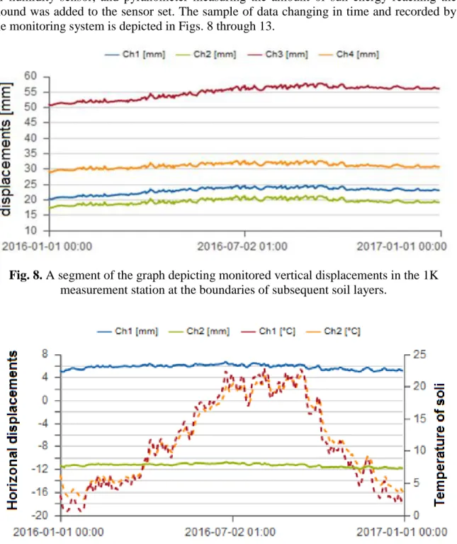
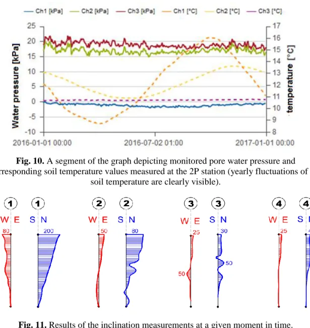
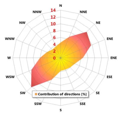
5. The sample of data recorded by the monitoring system
The Authors of this paper consider the monitoring system existing on the mound in the middle of 2019 to be sufficient. Until 2014 this system was undoubtedly incomplete. It
allowed for observation and measurement of various tambour deformations, however the coincidence of these measurements with weather conditions, and especially with insolation changing in a daily cycle and with wind directions predominant in Cracow was completely lost. Therefore the installation of the system was completed only when the independent weather station comprising of pluviometer, anemometer, air temperature sensor, relative air humidity sensor, and pyranometer measuring the amount of sun energy reaching the mound was added to the sensor set. The sample of data changing in time and recorded by the monitoring system is depicted in Figs. 8 through 13.
Fig. 8. A segment of the graph depicting monitored vertical displacements in the 1K measurement station at the boundaries of subsequent soil layers.
Fig. 9. A segment of the graph depicting monitored horizontal displacements in the 2O measurement station at the boundaries of subsequent soil layers accompanied by the soil
Fig. 10. A segment of the graph depicting monitored pore water pressure and
corresponding soil temperature values measured at the 2P station (yearly fluctuations of the soil temperature are clearly visible).
Fig. 11. Results of the inclination measurements at a given moment in time.
Fig. 13. Monitoring obtained wind rose for the mound location. 6. The future improvement concepts of the existing monitoring system
Until now the emphasis was laid upon the development of the monitoring system described by additional sensors and enrichment of the available data set. It seems, that the preparation of an optimised and unequivocal procedure allowing for efficient use of the gathered data constitutes the subsequent step, and this is undoubtedly expected by the mound owner. The point is that the various data types should be analysed in a complex manner in a single procedure taking into account the inherent intrinsic interactions and correlations present within the whole data set, instead of piecewise analyses performed on chunks of available data. It is also postulated, that the results obtained a posteriori, based on the measurements performed by the monitoring system sensors, should be used to improve the a priori assumed theoretical model. An extension of the user interface, and especially of the part on system “output”, would also constitute a significant improvement of the system as a whole. As noted above, the ultimate objective is to deliver to the evaluator a 3D risk map, showing the risk of soil reaching the ultimate limit state of bearing capacity or the mound slope stability, reproducing the whole volume of the monitored structure and accompanied by the risk level specified for each point on the map coincident with sensor location.
7. Concluding remarks
The man-made artificial mound described in this fact sheet is a very peculiar structure of very high historical value. Preservation of this mound in a state allowing for a year round tourist traffic calls for nonstandard actions assuring safe and reliable service in the future. Analysis of a structure of this type combines the problems of classical civil engineering (especially geotechnics), with problems of safety evaluation and systems engineering. The data available to the person appraising the technical condition of the structure of this type are characterized by the high variability of not only the statistical type but also due to the daily and yearly changes in the climate and weather conditions. The basic source of uncertainty is in this mound the layered structure of the hill, with very heterogeneous soil structure in all layers. Furthermore, the man made ground has its origins in many locations, thus its parameters fluctuate substantially. Finally, the soil
properties to a large extent depend on its humidity, and this in turn is affected by the seasonally changing weather conditions. This raises questions about the representativeness and reliability of the data collected. The limited accuracy of the measurements, due to the precision of the sensors used and their sensitivity to the weather conditions, is an additional source of uncertainty. The limitation of this type is especially important, as there is a risk of accumulating measurement errors, especially in the case of slope measurements. The uncertainty due to the limited credibility and random nature of the measurement data is aggravated by the inference uncertainty, based on the simplified model of analysis applied in practice. So far the inference based on the existing monitoring is supported by the statistical processing of the measured data and the analysis of the random processes describing the temporal evolution of the measured parameters. However, this variability is interpreted only locally in order to identify the possible trends and record the cases when the limit values are exceeded. It seems, that in order to qualitatively and quantitatively describe the deformation and mechanical properties of the mound structure, which change during the service time, it would be desirable to apply the measurement data gathered at discrete locations to develop and calibrate the 4D (three spatial dimensions and the temporal one) random field describing the soil behaviour in the whole volume of the mound. The 3D numerical model should also take into account the climate loads correlated with this field, and having the statistically determined values, based on the measurements supplied by the weather station.
REFERENCES
[1] Howiacki T., Mieszczak M., Jedlinski S. „System monitorowania konstrukcji Kopca Kościuszki w Krakowie”. Proceedings of the XXVII Scientific - Technical Conference “Structural Failures”, Międzyzdroje, May 20-23, 2015, pp. 327-334.
[2] Bednarski Ł., Sienko R. “Pomiary odkształceń konstrukcji czujnikami strunowymi”, Inżynieria i Budownictwo, 11/2013, pp. 615-619.
[3] Sienko R., Howiacki T., Maslak M., Pazdanowski M. “Structural Health Monitoring for historical Kosciuszko Mound in Cracow”. Case Study Fact Sheet No. WG4-4, COST Action TU1402 „Quantifying value of structural health monitoring”, Proceedings of the 9th Workshop, Dublin, Ireland, May 29-30, 2017, pp. 27-37.